A new pivotal technology is capturing the attention of telematics service providers and system integrators these days: dual-frequency GPS tracking. This development is poised to reshape the GPS tracking device market, setting new standards for accuracy and reliability. As manufacturers gradually embrace this innovation, understanding its implications and benefits becomes a necessity, especially for those who build GPS-based solutions and aim to stay at the forefront of innovation.
Dual-frequency GPS represents a significant technological leap with its potential to deliver next-level accuracy and reliability in location tracking. In this post, we delve deeper into this subject, exploring why this emerging technology is increasingly important in today's telematics.

Why dual-frequency GPS is a game-changer
While traditional GPS systems have sufficed for basic fleet management, the advent of dual-frequency GPS marks a substantial advancement in precision. There's a growing demand for highly accurate and dependable tracking solutions across a range of sectors, from transportation and logistics to personal security. Dual-frequency GPS significantly boosts accuracy, enabling it to pinpoint specific lanes rather than just the road a vehicle is on. In complex environments like construction sites or multi-story buildings, this technology can precisely locate employees using handheld devices. Such detailed accuracy transcends being a mere luxury; it's a transformative tool that has the potential to optimize workflows and significantly bolster safety protocols.
The most compelling advantage of dual-frequency trackers lies in their superior performance in challenging conditions. Urban environments, plagued by signal reflection and blockage due to high-rise buildings, benefit from the significant mitigation offered by dual-frequency GPS. Likewise, in dense forests, the L5 signal's higher power and greater bandwidth ensure more reliable tracking, effectively penetrating tree cover. Coupled with its ability to correct ionospheric distortions, dual-frequency GPS dramatically improves accuracy, offering consistent and reliable tracking where traditional systems falter. This advancement signifies a pivotal shift in GPS technology, enhancing functionality in previously challenging scenarios.
What is dual-frequency GPS?
Dual-frequency GPS is a major evolution in navigation technology, combining two satellite signal bands – typically L1 and L5 – to surpass the precision and reliability of standard GPS. This method effectively tackles common GPS issues like ionospheric signal distortion and obstructions in urban or forested areas. By leveraging both bands, dual-frequency GPS corrects errors that single-band systems can't, dramatically boosting accuracy and consistency in location tracking, making it a boon for high-precision and safety-critical applications.

This technology's journey involved major milestones in upgrading GPS satellites. The foundational step in this progression was the introduction of new civilian signals: L2C, L5, and L1C, complementing the legacy civil signal, L1 C/A. This expansion of signals was a part of a broader modernization initiative, requiring the incremental launch of new GPS satellites to replace older ones, with the full benefits realized as these signals reached operational status across a sufficient number of satellites. The L2C signal, launched with the GPS Block IIR-M satellites beginning in 2005, was designed specifically for civilian use, offering enhanced signal strength and reliability, particularly in challenging environments like urban canyons or dense foliage.
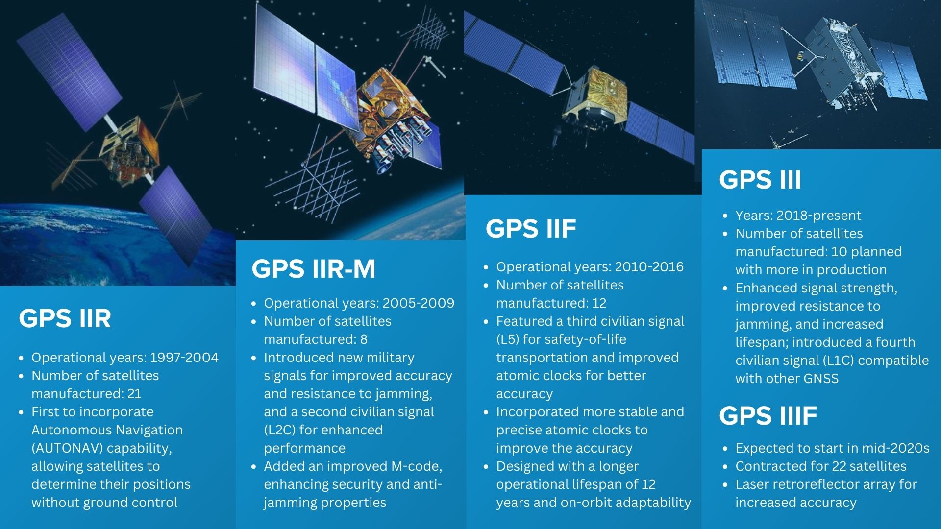
The L5 signal, introduced with the GPS Block IIF satellites in 2010, marked a leap in GPS capabilities, operating in a protected radio band for aviation safety services, offering higher power and greater bandwidth for improved jam resistance. The most recent addition, the L1C signal, launched with GPS III satellites in 2018, epitomizes international GNSS interoperability, featuring a modern signal design compatible with other global satellite navigation systems.
While GPS has seen substantial advancements with the integration of dual-frequency capabilities, other global navigation satellite systems (GNSS) have also progressed, albeit with varying degrees of advancement. The Russian GLONASS system, a long-standing counterpart to GPS, has undergone modernization but has not yet fully embraced dual-frequency functionality in the same way as GPS. The European Union's Galileo system, known for its high precision, incorporates dual-frequency capabilities in many satellites, offering an alternative with similar advanced features.
China's BeiDou system, rapidly expanding and evolving, has implemented dual-frequency technology in its newer satellites, positioning it as a strong competitor in the GNSS arena. Japan's QZSS, designed to augment GPS in the Asia-Oceania region, and India's NavIC, primarily focused on regional coverage, have also made strides in integrating advanced features, though their scope and global impact remain more limited compared to GPS, GLONASS, and Galileo.
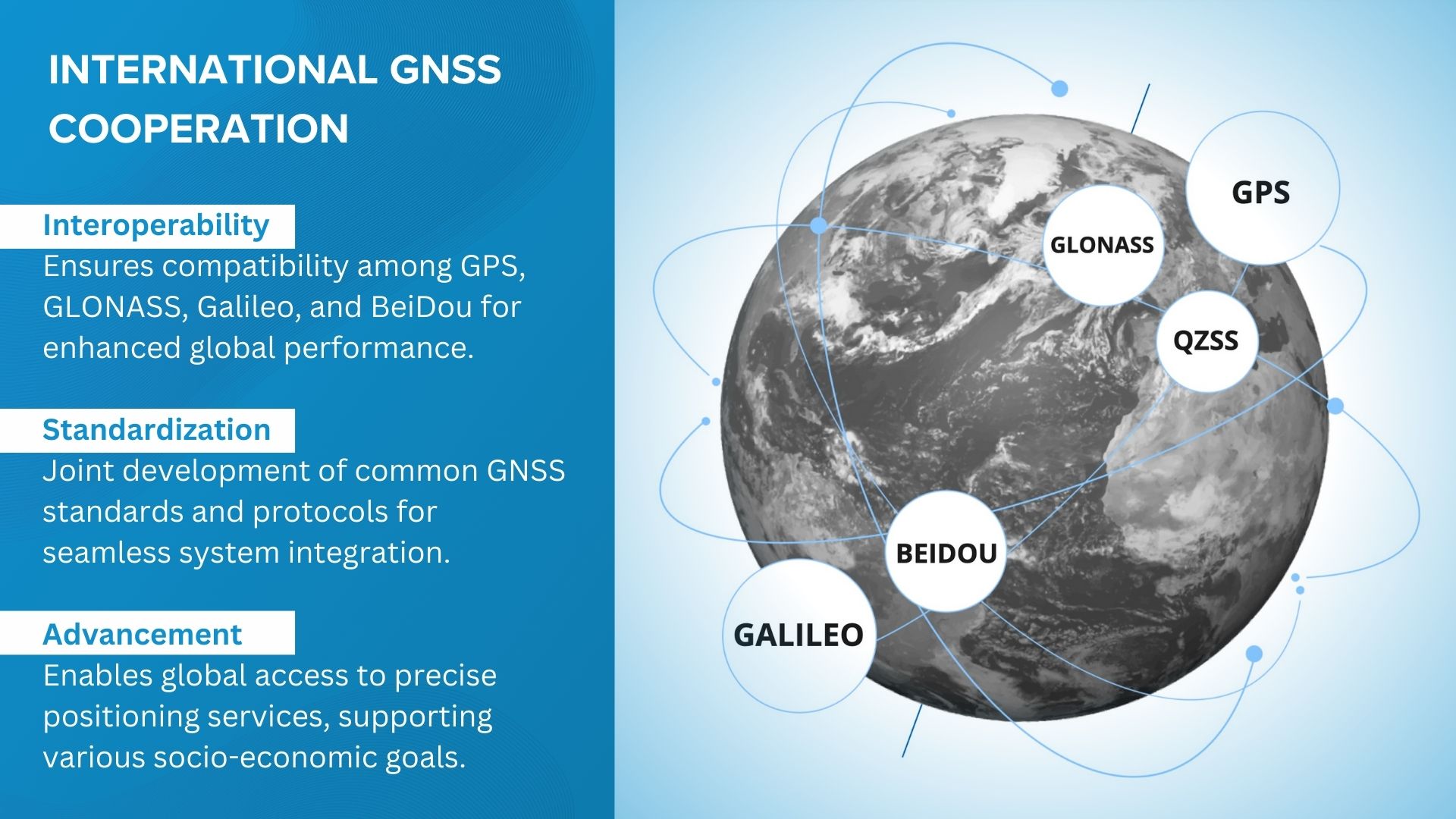
Modern GPS receivers, equipped to utilize multi-band signals and integrate data from various global navigation satellite systems, significantly advance accuracy and reliability, thereby enhancing GPS tracking capabilities.
The challenges of single-band GPS reception resolved with the dual-frequency approach
Transitioning from the legacy single-frequency approach to dual-frequency GPS, we are entering an era where tracking systems are more accurate and exceptionally reliable. How does this technology accomplish this feat, and what implications does it have for industries that depend on precision tracking?
To answer this question, let's enumerate the challenges of single-band L1 C/A GPS:
Ionospheric correction. The ionosphere, a layer of Earth's atmosphere, can cause delays and distortions in GPS signals. Single-band GPS systems struggle to correct these inaccuracies, as they can only estimate the ionospheric impact. Dual-frequency GPS, by using two different frequencies, can more accurately measure and correct ionospheric distortions, significantly improving positional accuracy.
Reflected signals. Single-band GPS receivers can be misled by signals bouncing off large structures or natural features, known as multipath errors. Dual-frequency systems are better equipped to identify and mitigate these reflected signals, enhancing accuracy in urban and natural environments.
Signal penetration. The ability of GPS signals to penetrate obstacles like dense foliage, urban structures, or even walls is limited in single-band systems. Dual-frequency GPS, particularly with the introduction of the L5 band, offers improved penetration capabilities, resulting in more reliable tracking in challenging environments.
Jamming resistance. Dual-frequency GPS systems are more resilient against unintentional interference and intentional jamming efforts, providing a more stable and reliable signal in various operational scenarios.
Improved Time-to-First-Fix (TTFF). The time it takes for GPS receivers to acquire satellite signals and determine the initial position (TTFF) is critical for many applications. Dual-frequency GPS can achieve a faster TTFF, which is especially beneficial for dynamic applications like vehicle tracking or emergency response.
Now that we've seen the broad strokes of how dual-frequency GPS elevates tracking capabilities, it's time to zoom in and examine each benefit more closely.
1. Ionospheric effects on GPS signals
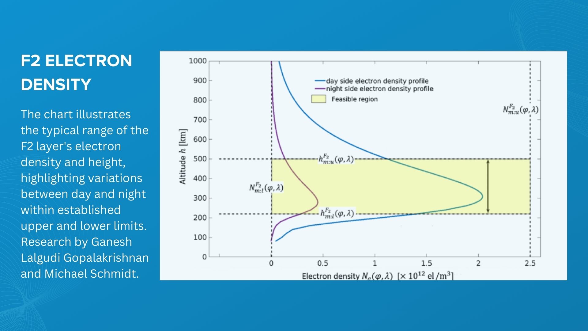
The ionosphere is a layer of Earth's upper atmosphere, located approximately 50 to 1,000 kilometers above the surface. It contains a high concentration of ions and free electrons, which affect radio wave propagation. For GPS signals, which are radio waves, this layer can introduce significant errors. These errors stem from the ionosphere's variable nature, influenced by factors like solar activity, time of day, and geographic location.
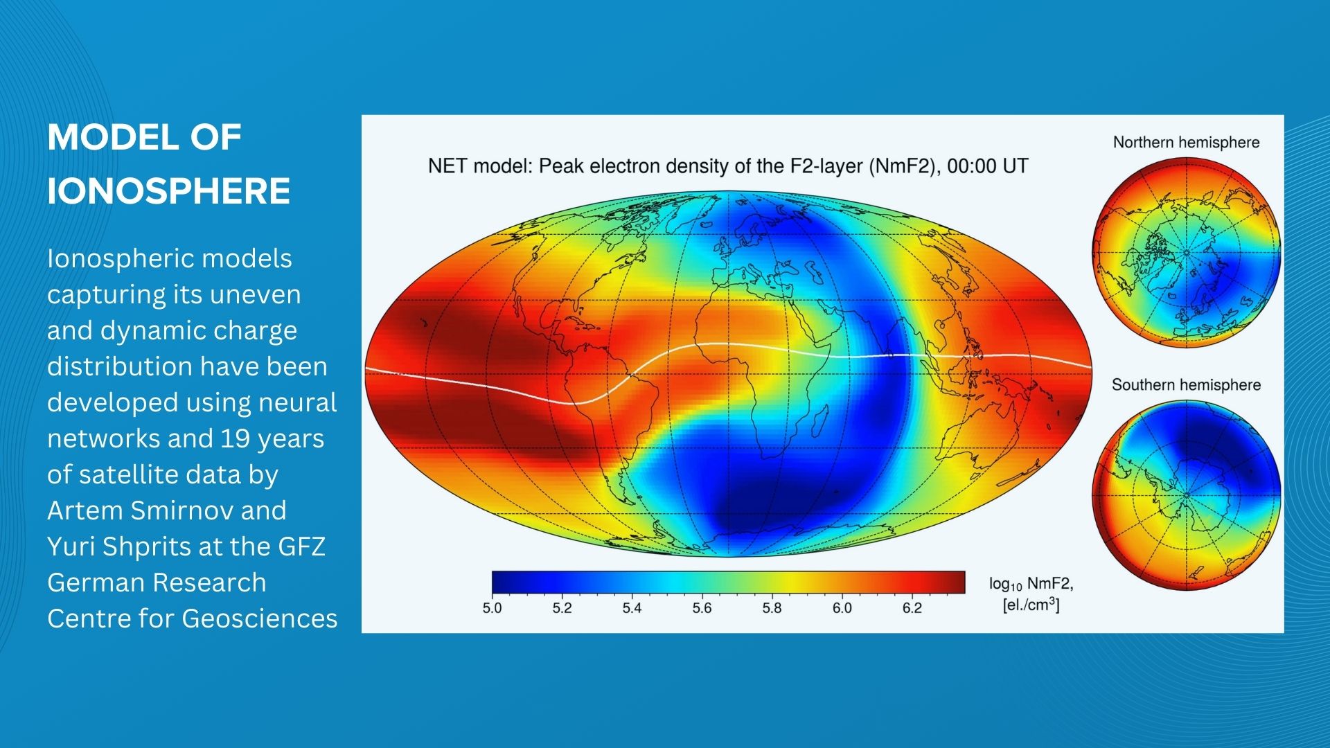
GPS signals, while traveling through the ionosphere, experience a delay and a speed change, leading to inaccuracies in position calculation. Among the various atmospheric layers, the ionosphere presents the most significant challenge for GPS accuracy due to its significant impact on signal delay, which can vary widely over time and space. This variability makes the ionospheric effect one of the largest error sources in GPS signal propagation, surpassing errors caused by other atmospheric layers.
Dual-frequency GPS addresses ionospheric errors by using two different frequencies: L1 and L5 (or L1 and L2, depending on the system). The key principle here is that the ionosphere affects each frequency differently. By measuring the time delay difference between these two frequencies, the GPS receiver can accurately calculate and remove the ionospheric delay from the signal.
Technically, the ionospheric delay is directly proportional to the signal’s wavelength and inversely proportional to its frequency squared. Therefore, the delays experienced by L1 and L5 signals will be different. By comparing these delays, the receiver computes a correction factor. This process, known as ionospheric correction, is not possible with single-frequency GPS receivers, which can only estimate ionospheric effects based on a model, leading to less accuracy.
In practical applications, such as fleet management, GPS tracking and autonomous vehicle navigation, the ionospheric correction capability allows for positional accuracy improvements from several meters (common with single-frequency GPS) to sub-meter levels, especially in areas with varying ionospheric conditions like equatorial and high-latitude regions.
2. Multipath errors and their impact on GPS accuracy
Multipath errors occur when GPS signals reflect off surfaces like buildings, large vehicles, or natural terrain features before reaching the GPS receiver. This results in the receiver capturing both the direct signal and the reflected signal, causing inaccuracies in position calculation. These errors are particularly prevalent in urban environments, where tall buildings create a "canyon" effect, and in mountainous or forested areas where natural terrains cause signal reflections.
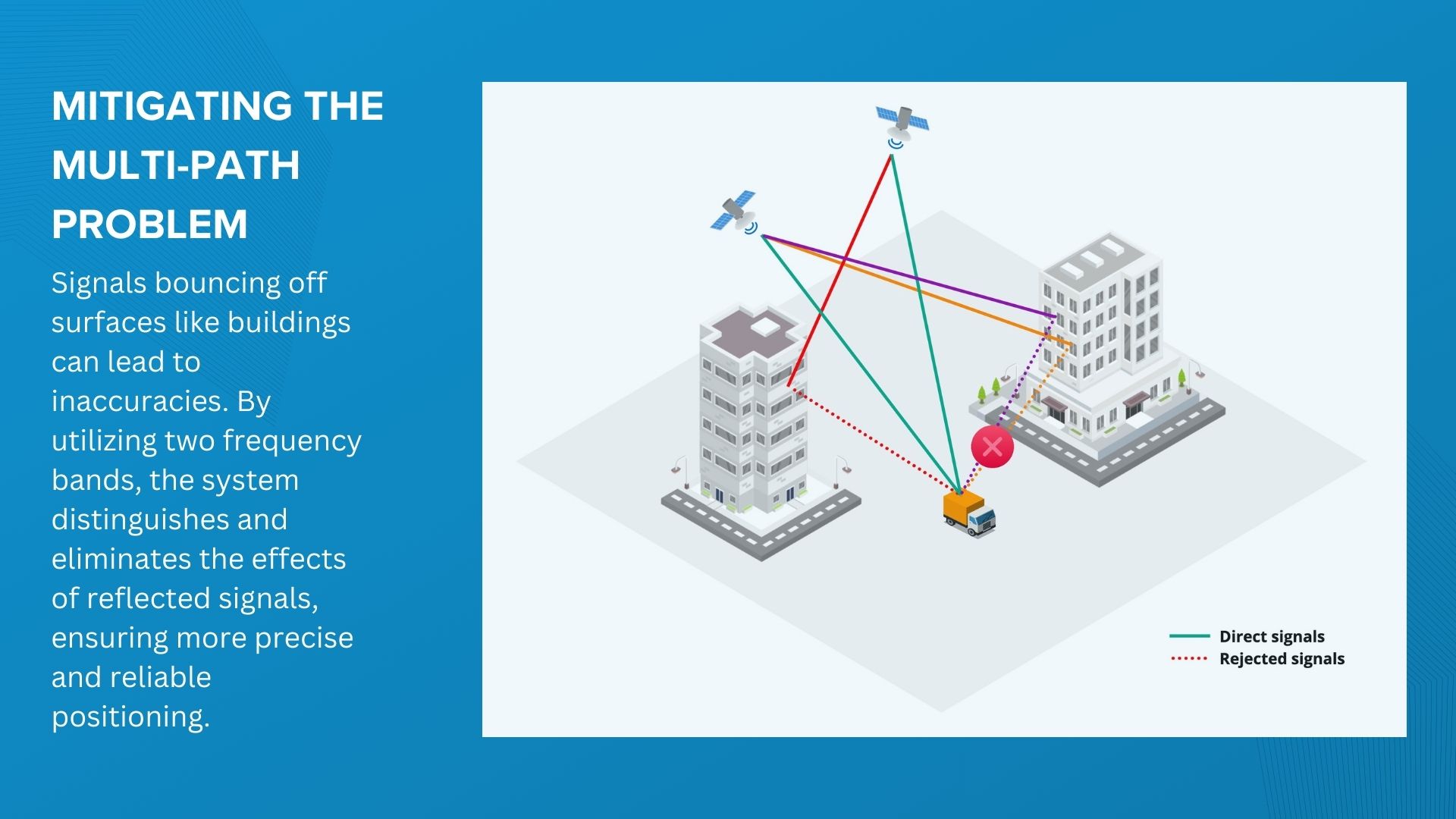
In fleet management and asset tracking, multipath errors can lead to positional inaccuracies, resulting in the misguidance of vehicle or asset locations. These errors are particularly acute in densely urbanized areas or areas with complex natural terrain, where the frequency of signal reflection is higher, resulting in more pronounced errors. For telematics service providers, this issue may be evident on mapping interfaces, where vehicles might seem to traverse through buildings instead of following streets, or their stationary positions could appear to shift erratically by a few meters with each location update.
Dual-frequency GPS systems address multipath errors by using the different propagation characteristics of two separate frequency bands (such as L1 and L5). The key to reducing multipath errors lies in the different ways these frequencies interact with and are affected by reflective surfaces. When GPS signals are reflected off surfaces, they travel a longer path to reach the receiver compared to direct signals. This additional travel causes a delay and a phase shift in the reflected signal. The crucial point is that this phase shift manifests differently across different frequencies. In dual-frequency systems, where two frequencies are used, the difference in how each frequency's signal is affected by reflection becomes a critical piece of information.
Receivers with dual-frequency support can distinguish between the direct and reflected signals more effectively than single-frequency receivers. The direct signal will have the same phase shift on both frequencies, while the reflected signal will exhibit different phase shifts on each frequency due to the varying wavelengths. By comparing these phase differences, the receiver can discern which part of the signal is direct and which is reflected. Once the receiver identifies the reflected signal, it applies correction algorithms to mitigate its impact. Essentially, the receiver 'subtracts' the distortions caused by the reflections from the overall signal, isolating the direct signal for accurate position calculation. This process is significantly more effective in dual-frequency receivers than in single-frequency ones, as they have two distinct data points (from two frequencies) to compare and analyze. To further refine this process, dual-frequency receivers can employ algorithms like wavelet transforms or adaptive filtering, which are particularly adept at handling non-linear and time-variant characteristics of multipath errors.
Adopting dual-band GPS trackers and dash cams enhances service quality for GPS tracking and telematics solution providers. Dual-frequency GPS ensures more reliable and consistent tracking in urban areas, where single-frequency systems are prone to errors. This leads to increased end-user satisfaction due to improved accuracy and reliability in location tracking, fostering trust and cementing long-term business relationships.
3. Enhanced signal penetration in dense urban infrastructure
The improved signal penetration in dual-frequency GPS systems is primarily attributed to two factors: the higher power of the L5 signal and the distinct propagation characteristics of different frequencies.
The L5 signal, a relatively newer addition to the GPS constellation, is transmitted at a higher power level compared to the L1 signal. This higher power makes the L5 signal more robust against attenuation (signal weakening) when passing through obstacles like foliage or building materials.
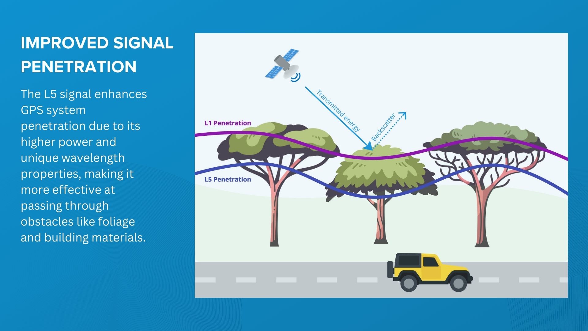
Additionally, radio frequency signals interact differently with materials depending on their wavelength. Generally, lower frequencies (longer wavelengths) are better at penetrating obstacles. The L1 frequency (1575.42 MHz) and L5 frequency (1176.45 MHz) have different wavelengths, and thus, their ability to penetrate common materials varies. The L5 frequency, being closer to the lower end of the spectrum used by GPS, can offer slightly better penetration capabilities.
For GPS tracking system users, the L5 signal's enhanced ability to penetrate tree cover and other materials ensures more reliable tracking in both forested and urban areas.
4. Signal jamming resistance
Jamming resistance refers to the GPS system's ability to withstand and operate effectively in the presence of interference, which can be intentional (jamming) or unintentional (noise from other electronic devices). GPS jamming involves broadcasting signals at the same frequencies used by GPS (like L1 or L5) to overpower or disrupt the legitimate GPS signals, leading to degraded accuracy or complete loss of GPS functionality.
Dual-frequency GPS enhances jamming resistance through multiple strategies. Utilizing diverse frequencies (L1 and L5), these systems are less vulnerable to jamming; if one frequency is compromised, the other can maintain data accuracy. This redundancy complicates jamming efforts as it requires simultaneous disruption of both frequencies, a task demanding greater complexity and power. Additionally, dual-frequency receivers use advanced signal processing to distinguish between authentic signals and interference, effectively filtering out jamming signals. The L5 signal's higher power transmission further bolsters resistance, making it more difficult for jammers to overpower the system, thereby enhancing overall interference resilience.
With their superior resistance to jamming, dual-frequency GPS systems are beneficial for anti-theft measures in vehicles and cargo, extensively used by sectors such as FMCG, logistics, car leasing, and equipment rental. Additionally, in areas susceptible to GPS jamming, such as near military installations or borders, dual-frequency GPS ensures more reliable and continuous tracking.
5. Reducing Time-to-First-Fix (TTFF)
Time-to-First-Fix (TTFF) is a measure of the time taken by a GPS receiver to acquire satellite signals and calculate a precise position after being turned on. It's a crucial metric in GPS performance, particularly important in environments where vehicles operate in areas with obstructed sky views, in employee tracking scenarios where individuals frequently move in and out of buildings or travel underground, and in asset tracking where battery-powered devices intermittently update their location.
Dual-frequency GPS reduces TTFF by simultaneously capturing signals from L1 and L5 frequencies, speeding up satellite identification and data decoding. This approach shortens TTFF compared to single-frequency systems. Additionally, the higher power and advanced modulation of the L5 signal ensure clearer and stronger signal quality.
Complementary technologies enhancing Dual-Frequency GPS capabilities
While the focus of our discussion is on the advancements and benefits of dual-frequency GPS, it's worthwhile to acknowledge other technologies that also address common GPS challenges. Specifically, we're looking at Dead reckoning and Real-Time Kinematic (RTK) GPS, each playing a unique role in the broader context of GPS tracking.
Dead reckoning: Filling the gap in GPS-challenged areas
Dead reckoning emerges as another pivotal technology in the realm of navigation, especially when considering its role alongside dual-frequency GPS. This technique estimates a vehicle's current position by analyzing data about speed, direction, and time elapsed from a previously known location. Utilizing inertial sensors, such as accelerometers and gyroscopes, dead reckoning continuously calculates the vehicle's movement, effectively compensating for GPS signal loss or inaccuracies. This is particularly important in environments where GPS signals are unreliable or non-existent, like tunnels or indoor parking structures.
Though dead reckoning addresses some inherent limitations of GPS in challenging urban environments, its relationship with dual-frequency GPS is one of complementarity rather than substitution. While dual-frequency GNSS enhances signal reliability and mitigates multipath effects, it can still encounter signal blockages in areas like underground passages. In such scenarios, dead reckoning steps in to bridge the gap, offering continuous positioning by relying on inertial data when GNSS signals falter. For instance, in a dense urban landscape, a fleet vehicle entering an underground parking lot may lose GPS signal; here, dead reckoning ensures uninterrupted tracking, maintaining the vehicle's location continuity. This synergy is particularly beneficial for applications in fleet management and vehicle insurance, where continuous and accurate tracking is crucial for operations like theft detection and driver behavior analysis. Together, these technologies offer a robust solution for navigation challenges in modern urban settings.
RTK: Precision beyond necessity for telematics
On the other end of the spectrum lies Real-Time Kinematic (RTK) GPS, known for its high precision in applications requiring centimeter-level accuracy, such as surveying and construction. It is a high-precision technique that involves a fixed base station and a mobile receiver. The base station calculates corrections for GPS signal errors, which are then transmitted to the mobile receiver. This process significantly enhances positional accuracy by resolving the integer ambiguity – the exact number of wavelengths between the satellite and receiver – a capability beyond standard GPS systems.
However, when it comes to vehicle telematics, RTK GPS is often seen as overkill. Its complexity, cost, operational range limitations, and intensive data processing requirements make it unsuitable for standard vehicle telematics, which generally demands only meter-level accuracy. Furthermore, maintaining a continuous, high-quality link to a base station, essential for RTK's functionality, poses a significant challenge for mobile applications like fleet management in urban or varied environments.
In summary, while RTK GPS's high precision doesn't practically benefit standard vehicle or asset tracking, there's notable potential in complementing dual-frequency GPS with dead reckoning. This combination enhances accuracy and reliability in challenging environments, offering a tailored solution for advanced navigation and tracking needs.
Impact of Dual-Frequency GNSS on the GPS tracking device market
The transition to dual-frequency GNSS in the GPS tracking device industry is a significant shift, driven by competitive advancements among chip manufacturers like MediaTek, Qualcomm, Broadcom, and u-Blox. This move towards dual-frequency GNSS is part of a broader trend where integration with other cutting-edge technologies such as BLE 5.x, and 5G cellular connectivity is becoming the norm. This convergence of technologies is not only fostering innovation but also leading to more cost-effective integrated modules.
Recent modifications in the GPS chipsets include support for multi-band, multi-system GNSS capabilities. This means that modern GPS modules are capable of accessing a variety of satellite systems and frequencies, such as GPS L1CA+L5, BeiDou B1I+B2a, GLONASS L1OF, Galileo E1+E5a, QZSS L1CA+L5, and NavIC. The advantage of this multi-system approach is evident: it enhances accuracy, improves signal reliability, and ensures better coverage, especially in challenging environments.
Recognizing the benefits of dual-band technology, top-tier manufacturers of GPS trackers and dash cams, including companies like Queclink, Suntech, and Ruptela, are beginning to incorporate this technology into their products. This adoption is not just limited to experimental or high-end models but is increasingly becoming a standard feature in flagship models and top-performing device series.
For instance, Teltonika, a renowned name in the telematics industry, has introduced its first device supporting L1/L5 frequencies, the Teltonika FMC880. This move by Teltonika is indicative of the industry's broader shift towards embracing dual-band GNSS, recognizing its potential to significantly enhance tracking capabilities and overall device performance.
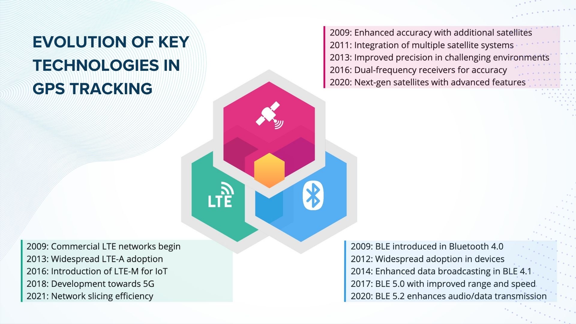
The transition to dual-band GNSS is reshaping the GPS tracking device market, setting new standards for accuracy and reliability. As manufacturers continue to integrate these advanced modules into their products, we can expect a new wave of GPS tracking devices that are not only more precise but also more versatile, capable of functioning seamlessly across different geographic regions and in various operational conditions.
Moreover, this trend is likely to accelerate with the ongoing advancements in satellite technology and the increasing demand for high-precision, reliable tracking solutions in various sectors, including logistics, automotive, personal security, and more. The integration of dual-band GNSS is a clear step towards future-proofing GPS tracking devices, ensuring they remain relevant and competitive in an ever-evolving technological landscape.
