This function allows granting access rights to the main account for multiple additional users at once. It is possible to choose which devices each of these users will have access to, as well as assign them specific roles with permissions for viewing telematic data from devices, generating reports, managing vehicles and employees, working with geofences, plugins, etc.
Such users do not have an established name, but in most cases, they are referred to as sub-users, as well as subaccounts or sub-users. The main account from which the rights delegation is performed is called the owner in this case. In the user interface, the Users name is used for sub-users. However, to avoid confusion, in this article we will use "Sub-users" as the name of the owner account users.
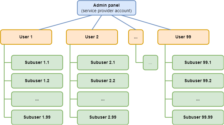
In general, the hierarchy of accounts within the platform looks like this:
Sub-users
As seen from the above diagram, a sub-user is a special account belonging to the owner account.
For each sub-user, you can specify:
- List of accessible devices.
- The sub-user will see only those devices to which you grant access. The owner account's general list of devices (as well as other sub-users) is not accessible to them.
- Access to one device can be granted to multiple sub-users simultaneously.
- List of accessible geofences and places.
- The sub-user will see only those geofences and places to which you grant access. The owner account's general list of these entities (as well as other sub-users) is not accessible to them.
- Similar to devices, access to one geofence or place can be granted to multiple sub-users. By default, all places and geofences are marked accessible for new sub-users.
- Role
- Regulates the sub-user's level of access to information. For example, creating, importing, editing, and deleting places and geofences are available according to the assigned roles. The full list of access options by roles is available below in the "Adding a new role" section.
As a subordinate account, a sub-user cannot:
- Have the owner role or any rights of this role (this role belongs exclusively to the main user).
- Delete devices.
- Create their sub-users.
- Have their own devices not accessible to the owner's account.
- Create geofences and places not accessible to the owner's account.
- Restrict access to their account for the owner's account.
Everything created by a sub-user becomes available to the higher-level account and effectively belongs to it.
- If a sub-user registers a device, it is registered in the master user's account, and the sub-user receives rights to view trips and telematic data, as well as (depending on the role) to perform settings.
- Rules created in "Alerts" are visible to the master user and other sub-users who have access to the necessary device because the rules are tied to the device.
- Geofences and places created by a sub-user also belong to the master user and are visible to all other sub-users who are allowed to work with geofences and places.
- Vehicles and employees created by a sub-user are also visible to the master user.
- If a beacon is assigned to a vehicle or employee, these objects will be visible only to the master user and sub-users who have access to that beacon.
- If a vehicle or employee is not linked to a beacon, they are visible to all sub-users.
Managing Access Levels Using Roles
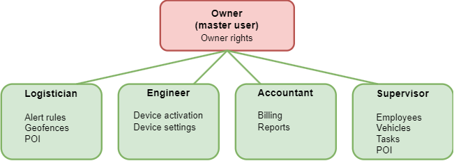
The set of operations for sub-users can be limited by the owner through customizable roles. Each role is assigned available operations.
Example role distribution:
Restricting Sub-User Access to trackers
For each sub-user, the owner can specify which beacons (and related data) will be accessible. The sub-user will not be able to see beacons that are not available to them and the associated information (e.g., tasks).

Restriction of Sub-Users' POI (Places) and Geofences.
For each sub-user, the owner can specify which entities of POI (aka Places) or geofences (and related data) will be accessible. The sub-user cannot see POI or geofences that are not available to them and the associated information.

POI
The list of POI displays all POI in the owner's account. By default, sub-users have access to all POI created by the main user. All new POI created by the sub-user (with the necessary role) become accessible to the owner as well.
The presence of access affects the display of POI in the following sections:
- “Monitoring” list of POI
- “Dispatcher” list of POI
- “Advanced Analytics” list of POI
- “Field Service” subsection “Places”
- “Reports”: Report settings for "POI Visits". When creating a report and editing a previously created report, only POI accessible to the user are displayed. When viewing a previously created report, only the data on which it was originally generated is shown. Report on "Check-ins", column with POI. The place is not displayed in the report if the user does not have access to it. When viewing a previously created report, only the data on which it was originally generated is shown.
Geofences
All new geofences created by the sub-user (with the necessary role) are accessible to the owner.
The presence of access affects the display of geofences in the following sections:
- “Tracking,” list of geofences
- “Operator,” list of geofences
- “Advanced Analytics,” list of geofences
- “Alerts” list of geofences for control. When creating a new rule and editing a previously created rule, it is possible to choose only geofences accessible to the user. After turning off access to the geofence, event control rules are no longer checked inside this geofence. Events recorded in the geofence before turning off access are available for viewing.
- “Reports”: Report settings for "Geofence visits". When creating a report and editing a previously created report, only geofences accessible to the user are displayed. When viewing a previously created report, only the data on which it was originally generated is shown. Report on "Check-ins", column with geofences. The geofence is not displayed in the report if the user does not have access to it. When viewing a previously created report, only the data on which it was originally generated is shown.
Adding a new sub-user
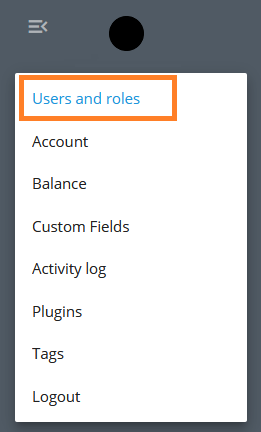
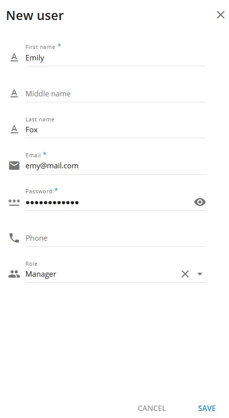
Go to the 'Access' section
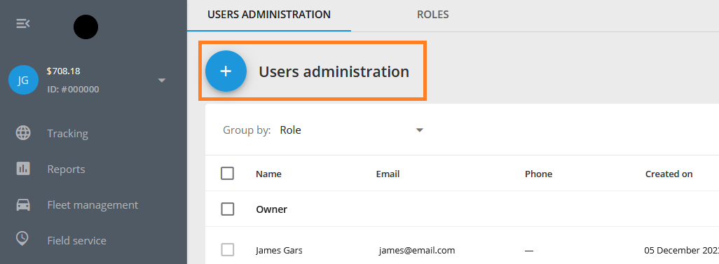
Create a new user.
Choose a role for the sub-user. If the required role is not yet created, you can remove the assigned role. You can change the role later.
Fill in the owner's name, surname, phone number, and email. It is recommended to provide a valid email as it is used for password recovery.
Set a password - at least 6 characters.
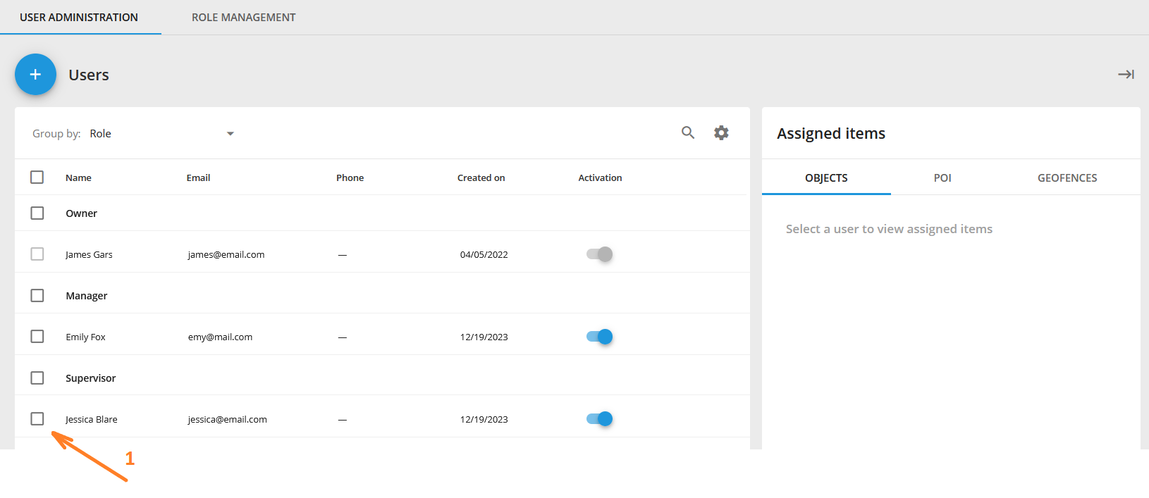
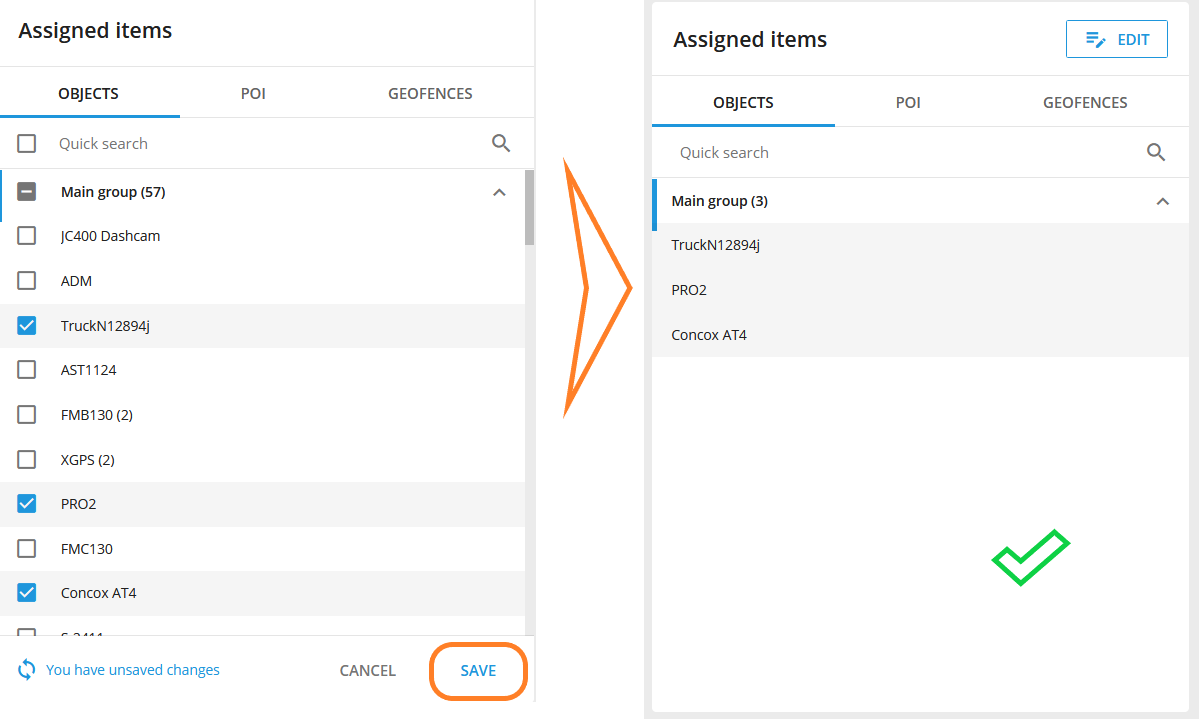
After creating the sub-user, select the list of beacons available to them.
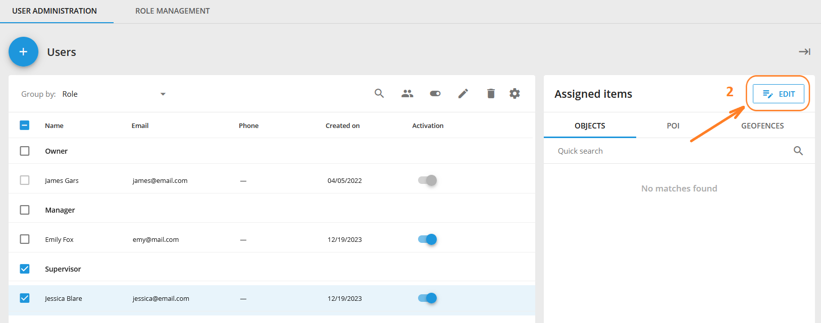
To edit the list of objects (trackers) or add them, select the desired users on the left side of the list and the edit button will appear on the right side of the list. This works not only for objects but also for Geofences and POI.
Adding a new role
Go to the 'Roles' tab, click on the add role button (the button with the 'plus' sign +).
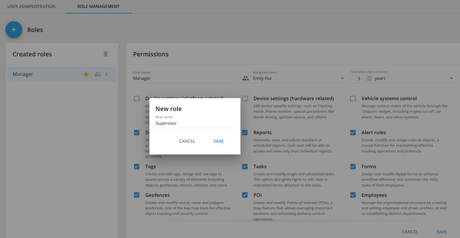
Think of a name for the role, select the necessary access rights and press save. All rights are divided into three types: owner, basic and additional.
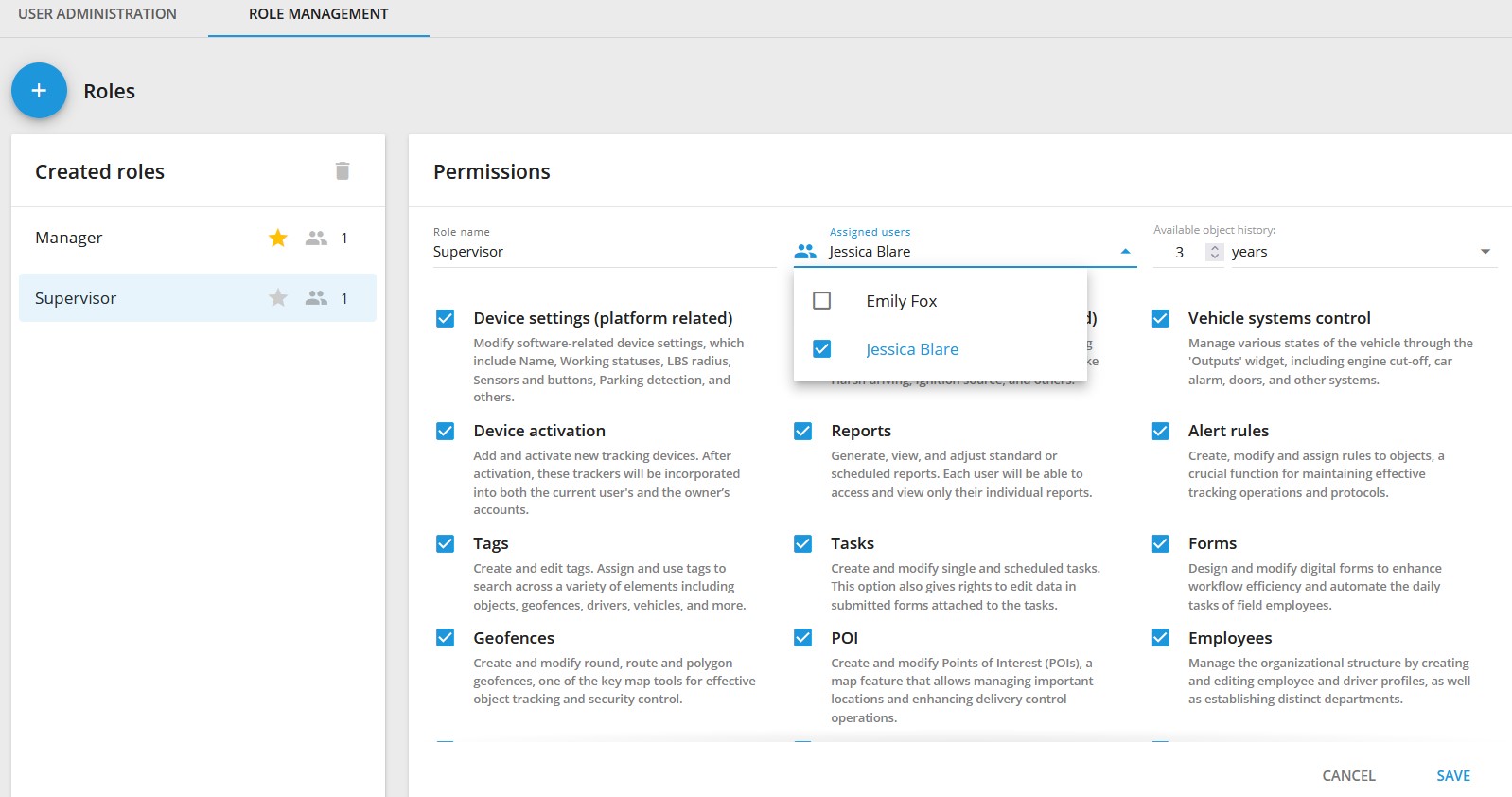
Owner Rights
Available only to the account owner (main user) and cannot be assigned to other roles. These include:
- edit user
- manage beacon groups
- manage retranslators
- change tariffs
- activate users
Basic Rights
Available to all roles and cannot be disabled. These include:
- map tools (layers, route planning, etc.)
- trip and event history
- service operations
- interactive widgets (change work status, change output states, etc.)
- linked data (assigned tasks, control rules, etc.)
Additional Rights
Configured individually for each role. These include:
- Device Settings (platform-related) - modify device settings related to software, including name, work status, LBS radius, sensors and buttons, parking detection, and more.
- Device Settings (hardware-related) - edit settings for specific devices, such as tracking mode, phone number, special parameters like harsh driving, ignition source, and others.
- Vehicle systems control- control various vehicle states through the "Outputs" widget, including engine shutdown, car alarm, doors, and other systems.
- Device activation - add and activate new tracking devices. After activation, trackers will be enabled for both the current user's account and the owner's account.
- Reports - create, view, and configure standard or scheduled reports. Each user can only view their individual reports.
- Alert rules - create, modify, and assign rules to objects - a feature for maintaining efficient operations and tracking protocols.
- Tags - create and edit tags. Assign and use tags to search for various elements, including objects, geofences, drivers, vehicles, and more.
- Tasks - create and modify individual and scheduled tasks. This option also grants the right to edit data in forms attached to tasks.
- Geofences - Create, edit circular, route, and polygonal geofences - a key mapping tool for tracking objects and ensuring security.
- Places - create and edit points of interest (POI) - a map function that allows managing important locations and improving delivery control operations.
- Employees - manage the organizational structure, create and edit employee and driver profiles. Create departments.
- Vehicles - create, modify, and distribute fleet profiles by department. This option also allows assigning drivers to specific vehicles.
- Billing and Payments - provide financial and accounting groups access to payment management, transaction history, and low balance alert settings.
- Video telematics - access live streams, view events, and play videos from DVRs and MDVRs. Enhances road safety and fleet security.
- Weblocator - allows sharing the real-time location of tracked objects with third parties through a plugin that can be embedded in a website or application.
- Courier on the map - allows customers to track their orders on the website, offering real-time location updates and courier route progress.
View History
This setting allows limiting the period for viewing device history. It cannot exceed the period defined by the device tariff.